
Table of Contents
Outdated building documentation leads to unnecessary added costs
How to get useful 3D BIM models for existing buildings?
Reduce construction costs and risks in refurbishment projects
Outdated building documentation leads to unnecessary added costs
A common challenge in the private and public sector, which owns and manages a vast number of buildings and square meters across wide territory, is that one has to deal with outdated, inaccurate, or plain simply unavailable building information.
As Built information based on older drawings and documents is often unreliable and lacking. Simple 2D drawings might be wrong or missing recent changes made to the buildings, resulting in costly setbacks. These range from a wrong basis to be used in project planning, redesign and tendering processes, to inefficient operation and maintenance workflows throughout the building life-cycle.
Even key data like the area of your buildings, or vacated space is highly unreliable and you're probably paying for space you don’t have. Likewise, you might be missing out on rental income for space you didn’t know you have. In some cases, unreliable documentation can lead to severe consequences (see image below on the example of undocumented partition walls blocking the expected fire-escape route).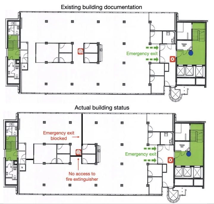
Outdated documentation leads to costly deviations
Over the last years, the introduction of building information modelling (BIM) across the construction industry has promised to resolve these challenges.
By structuring important and useful information together with object-oriented 3D models, BIM enables to optimise the way buildings can be operated: reducing waste, energy, time, money and risk across the building life cycle.
How to get useful 3D BIM models for existing buildings?
There are basically two ways to go:
- Creating basic BIM models out of the existing 2D drawings, or
- Laser-scanning the existing buildings and creating BIM models directly out of the laser scan data.
Both, however, have their pitfalls.
When creating 3D Models (BIM) from outdated 2D drawings, all the outdated information is replicated and the model itself ends up not providing the value intended. Similarly, when BIM models are created out of laser scans, errors and overlooked misplacements, such as imprecise modelling and missing elements, happen frequently and remain overlooked.
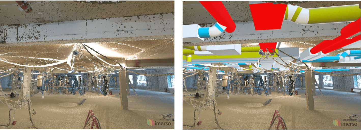
- First, Imerso automatically finds discrepancies between the initial (rough) BIM models and the 3D scan data.
- Then, with one click, BIM elements can be updated to the actual as-built condition.
.png?width=720&height=440&name=Imerso%20As%20built%20update%20(1).png) Imerso detects mismatches between model and reality and updates the BIM elements to their correct position.
Imerso detects mismatches between model and reality and updates the BIM elements to their correct position.
Reduce construction costs and risks in refurbishment projects
The resulting As Built BIM model is a reliable geometric twin of the building. In the case of upcoming refurbishments and renovations, the following check should also still happen:
- Imerso automatically finds collisions between the current state of the building and the planned changes. The collision check between the actual state of the building and the planning intention avoids costly change orders during construction.
 Imerso detects future clashes between the current building status and the new design intent.
At the forefront of adopting 3D scanning to digitise existing buildings and to keep the building plans up-to-date, are the two Norwegian counties Møre og Romsdal and Vestland Fylkeskommune.
Using Imerso as part of their digital twin strategy, they ensure that their building plans are accurate and the data shared with consultants, contractors and other third parties are reliable. To facilitate laser scanning and make it possible to roll it out over many properties, Imerso has an integrated feature that lets anyone do laser scanning, without having to be an expert in this field.
Now, facility managers, as well as students during their summer jobs, can take over this part. Because Imerso’s solution is cloud-based and works with open file formats, the teams can easily use the solution to store 3D scan data, collaborate across teams online and exchange data with other systems.
All this enables the project manager or facility manager to have better control of the building assets at any given time — and verify how well the models reflect the current reality of the property.


.png?width=200&height=200&name=Lean%20Guide%20compressed%202%20(1).png)
Comments